General
Awareness Updates – November 2009
Miscellaneous-2
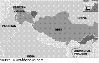
Cracks in the Faultline
 In the last few
weeks, relations between India
and China
have hit a new low. The two neighbours have engaged in a war of words over the
contentious boundary dispute that has defined the bilateral relationship since
the 1950s.
In the last few
weeks, relations between India
and China
have hit a new low. The two neighbours have engaged in a war of words over the
contentious boundary dispute that has defined the bilateral relationship since
the 1950s.
In recent months, China has opposed the visits of
President Pratibha Patil, Prime Minister Dr. Manmohan Singh, and Tibetan
spiritual leader the Dalai Lama to Arunachal Pradesh, which it claims as its
own. In fact, China
has always painted the Dalai Lama as anti-national and has on occasions,
referred to him as a terrorist.
Also, China has consistently refused to
issue visas to officials from Arunachal Pradesh. The last several months have
also seen an increase in the number of incursions by Chinese troops into areas
that lie on what India
considers its side of the Line of Actual Control.
On a recent visit to Arunachal
Pradesh, Dr. Singh described the state as “[Our] Land of the Rising Sun”. The
Prime Minister mostly visited army installations in the state and took stock of
military preparedness and also announced packages for the army serving in the
state.
The Chinese brazenly protested and
asked the Government of India to desist from making such visits (to disputed
territories) and voicing such statements. The Government of India, which didn’t
take kindly to the Chinese government’s remarks, reiterated that the Prime
Minister of India is free to visit any part of his country.
Before we go into the background of
the boundary dispute between the two Asian giants, let us first look at their
great rivalry that now spans continents and oceans.
Rivalry
The story of China, past and
present, evokes strong passions. Throughout the ancient and the medieval
periods, the wealth of the Middle Kingdom was the subject of curiosity and
envy, especially among the Europeans. The age of colonialism saw European powers
cut the ‘Chinese watermelon’ into spheres of influence.
In modern times,
the Middle Kingdom, putting back centuries of humiliation and subjugation, has
emerged as one of the biggest powers in the global military, political, and
economic order.
Another country that almost matches
this description is India.
Today, the two Asian giants have become the cynosure of the world’s eyes: China
and India are not only home to the largest and second largest populations
respectively but also have the fastest and second fastest growing large
economies respectively.
Today both India and China have emerged as rivals in the
global geo-strategic, political, economic, and military space. The two
countries have made no secret of their ambitions to become major global powers.
In the race to grab raw materials and energy resources to fire their
fast-growing economies, the two countries fiercely vie with each other in
different parts of the world.
Regarding the competitive nature of
the relationship between India
and China, an observer said:
“Both India and China are
engaged in competitive regionalism and they face each other on many platforms.
Although India
has thwarted Chinese pressure and gained a confident foothold in ASEAN, there
is an atmosphere of apprehension elsewhere. While India has been provided an
‘observer status’ in the SCO with China’s help, allowing China a similar status
in SAARC may undermine the sub-regional balance of power. Interestingly, India’s Mekong Ganga Project excludes China, while China’s
own Greater Mekong Project does the same to India. In addition, wherever India looks for
new partners in search for its ‘energy security’, Chinese companies step in
with promises of lucrative investments and often walk away with the contracts.”
For decades now, India and China have shared a frosty
relationship, the most important reason for which is the dispute over the
boundary that divides the two countries. To understand the contentious boundary
dispute between India and China, the reader should appreciate the relationship’s
past, one that still haunts India’s
policy-makers.
Birth of the faultline
The origin of the boundary dispute
between India and China lies in the British
Empire’s response to the colonial aspirations of the Russians. In
the 19th century, the British were wary of the expansionist designs
of Russia, its rival in the
race for colonial aspirations in Asia. To
counter the Russian threat, the British sought to establish a forward defensive
line in the northern region.
The 1846 Treaty of Amritsar, by which
the British gave Kashmir to the Dogras of Jammu, provided the British with the
opportunity to fix the security on Kashmir’s northern and eastern borders with
Xinjiang and Tibet.
(Tibet,
though nominally subject to Chinese suzerainty, was an autonomous theocracy.
From this it is clear that Tibet
was never considered an independent country.) The entire British exercise was
aimed at shoring up Chinese control over Tibet and preventing Tsarist
expansion. However, the British failed to ecognized on the chance.
In 1913, the British mooted a
tripartite conference between Tibet,
China, and Britain, in
Shimla. While the Tibetans, who were at loggerheads with their Chinese
suzerains, were keen on the outcome, the Chinese did not seem so. The British
delegation was led by Sir Henry McMohan, foreign secretary to the Government of
India.
According to an agreement reached
at the convention, Tibet
was to be divided into three zones. China’s
suzerainty over Tibet was
ecognized; however, China
agreed not to convert Tibet
into one of its provinces. The boundary that followed this convention is the
McMohan Line. This boundary now extended British
India
up to the edge of the Tibetan Plateau.
Today China
is India’s
biggest trade partner, reflecting the need to make business the primary idiom
and pivot of rapidly expanding ties. The Chinese, however, repudiated the
Shimla Convention on the grounds that it could not accept the proposed
Sino-Tibet boundaries. Now another agreement was reached on the frontier
between British India and Tibet
from Bhutan
eastwards. Today, only this boundary is known as the McMohan Line. However, it
was only in 1937 that the McMohan Line was shown as the official boundary.
The Chinese attitude to the Shimla
Convention could be summed up in the words of Zhou En-Lai, premier of China, who in
1958 said: “The McMohan Line was wholly illegal. The Tibet-Assam border was
drawn up in secret agreement between the British and the Tibetan
representatives and far from being on the agenda of the Shimla Convention was
entirely unknown to the Chinese delegate. Further, China never signed the Shimla
Convention.”w
Cartographic Aggression
In 1949, the Communists came to
power in China.
All through the 1950s, the Chinese professed friendship with India. When Jawaharlal
Nehru visited Peking in 1954 (the Panchsheel
was signed in the same year; See box in Page No.16, What is the Panchsheel?),
he protested at the errors in the demarcation of boundaries in the Chinese
maps. But the Chinese brushed aside his protest claiming that the errors were
just an oversight on the part of the cartographer.
Outwardly, the Chinese continued
their “cartographic aggression”. In 1958, China’s official maps included four
divisions of the North East Frontier Agency (NEFA), Ladakh, and parts of Uttar
Pradesh (now in Uttarakhand) as part of its territory.
The same year, China announced the completion of a 750-mile
road in western China
of which a 112-mile stretch lay in Aksai Chin. India
saw Aksai Chin as part of Jammu & Kashmir, and therefore, part of India. But it
was only when China made
this announcement that India
learnt of the road and the annexation it seemed to represent. The Chinese had
managed to work for several months on Indian Territory without India’s
knowledge. In addition to this, policy-makers in India were troubled by regular
incursions by the Chinese army, which became pronounced towards the end of the
decade.
India’s Hour of Humiliation
On October 20, 1962, China launched a swift and massive invasion
across the McMohan Line into India’s
north-east. The Indian Army, ill-prepared, poorly equipped, and short-staffed,
was routed. In a nutshell, India
faced its hour of humiliation.
After descending with ease into the
foothills of Assam and
inflicting a humiliating defeat, China declared a ceasefire on
November 21, 1962. At the time of ceasefire, the Chinese were 20 km across the
McMohan Line as well as the Ladakh Line. This left 14,500 sq km of Indian
Territory in China’s
hands. In the 1962 war, China
occupied large swathes of territory, including Tawang in Arunachal Pradesh. The
dispute was most critical with regard to Tawang and Longju. China argued that Tibet
had previously exercised authority over these areas and that such authority
should be transferred to China.
Nehru saw China’s attack as a betrayal, for when Mao’s
Communists came to power (1949), he had personally campaigned for China’s
international acceptance as well as for its right to a seat at the United
Nations Organisation (UNO).
So betrayed was Nehru by Mao’s war
that he had this to say on the day the Chinese invaded: “Perhaps there are
not many instances in history where one country has gone out of her way to be
friendly and cooperative with the government and people of another country and
to plead their cause in the councils of the world, and then that country
returns evil for good.” Nehru
believed that as Asians with no history of territorial conquest, but a similar
history of injury and exploitation at the hands of the European imperial
powers, India and China could
together work for international peace and a stable world order. But as history
records, his faith, though touching, was misplaced.
In the 1962 War, China
occupied 38,000 square kilometers of land in the remote Aksai Chin plateau
(Western Sector). India also
says Beijing is illegally holding 5,180 square
kilometers of land in Kashmir ceded to it by Pakistan in 1963. In the Eastern
Sector, China claims about
90,000 sq. km. of Indian territory. Of all the
three sectors, the Central Sector (comprising parts in Uttarakhand) is not as
contentious as the other two.
Thaw in the Frigid Relationship
For almost two decades after 1962, India and China remained indifferent to each
other. The process of normalisation of relations between the two countries
started with the visit of Rajiv Gandhi to China in 1988. Since then, every
visit by the top leadership of the two countries has resulted in the setting up
of new milestones in India-China relations and helped in what is aptly called
Graduated Reciprocation in Tension Reduction (GRIT). Also, in the past few
years, relations have warmed up considerably with greater cooperation in
politics, economy, and culture.
In 2003, A. B. Vajpayee’s China visit
ushered in greater play between the two sides. During Mr. Vajpayee’s visit, ten
agreements and a ‘Declaration on Principles for Relations and Comprehensive
Co-operation between India
and China’
were signed. Through the latter, India
recognised the Tibet Autonomous Region as a territorial part of China. In a
quid pro quo, China
recognised Sikkim as an
integral part of India,
thus closing another major contentious chapter.
During Chinese Prime Minister Wen
Jiabao’s visit in 2005, a ‘Strategic and Cooperative Partnership’ between the
two nations was signed. The agreement on political parameters and guiding
principles on the India-China boundary question, signed during Mr. Jiabao’s
visit, laid down the parameters and principles for future discussions to
explore the political settlement of the boundary question (See Box - The Ten
Guiding Principles for Settlement of the Boundary Dispute between India and
China). The guiding principles for delineating the border are based on “mutual
understanding, mutual adjustments” of the two sides. The same, when applied
on the ground, could enable India
to make the needed concessions in Aksai Chin through which the important
Xinjiang-Tibet road runs.
At the same time, it could also
enable China to concede
Indian control over Arunachal Pradesh, particularly the Tawang Tract, which has
been administered by India
for over half a century. This would, to use a Chinese diplomat’s words, lead to
a “fair and reasonable solution acceptable to both countries on the basis of
mutual respect and equality”.
India has consistently
maintained that populated areas cannot be traded while settling the boundary
dispute with Beijing.
The idea implicit in the statement is that Tawang as a populated area cannot be
exchanged for land in Aksai Chin or other area of the border.
Political Will
In recent months, the Government of
India has taken some significant measures towards building a strong defence in
the Arunachal sector in the wake of recent reports of improved Chinese
infrastructure close to the borders of the state and faster Chinese troop
deployment capabilities.
Probably the single most important
move made by the Government of India has been the appointment of the retired
Indian Army Chief General J. J. Singh as the Governor of Arunachal Pradesh in
February 2007, an indication that the Government of India does not want to take
matters lightly in the border state. (In all NE states the Governor’s House is
an alternate centre of power.)
India and China have had
11 rounds of negotiations to settle the boundary dispute. What the two
countries need is a refreshing break from the past, when the two sides argued
on the basis of historical precedent and legal claims. Today, both the sides
need to acknowledge that there has to be “give and take” in resolving
the intractable boundary dispute.
Says M. K. Narayanan, India’s National
Security Advisor: “The challenge for our national leadership is to harmonise
reality with sentiment, pragmatism with unhistorical belief and national
aspirations with imperialistic legacies. To be able to do this we first need to
extricate such sensitive and critical issues from the ambit of partisan
politics. The responsibility for this lies with the government of the day,
which alone can orchestrate such an exercise. By doing this, we can once again
bring into alignment our political objectives, with military means and reality.
We can then negotiate from a position of strength and give ourselves secure,
defensible and natural boundaries in the north at least. And who knows, this
may even lead to lasting good relations between the two great countries.”
Let us hope that
the NSA’s words come true. Amen.
The
Ten Guiding Principles for Settlement of the Boundary Dispute between India and China*
1
The two sides will resolve the
issue through friendly consultations. Neither side shall use force against the other.
2
The two sides should, in
accordance with the Panchsheel, seek a fair solution through consultations.
3
Both sides should make
mutually acceptable adjustments to their respective positions to arrive at a
final solution, covering all sectors of the boundary.
4
The two sides will give due
consideration to each other’s strategic and reasonable interests.
5
They will take into account
historical evidence, practical difficulties and reasonable concerns of both
sides, and the state of border areas.
6
The boundary should be along
well-defined and easily identifiable natural geographical features to be
mutually agreed upon between the two sides.
7
In reaching a boundary
settlement, the two sides shall safeguard interests of their “settled”
populations in the border areas.
8 Within the agreed framework of
the final settlement, the delineation of the boundary will be carried out
utilising modern cartographic and surveying practices.
9
Pending a settlement of the
boundary question, the two sides should strictly respect the Line of Actual
Control (LAC) and work together to maintain peace and tranquility in the border
areas.
10
The Special Representatives on
the boundary question shall continue their consultations in an earnest manner
with the objective of arriving at an agreed framework for a settlement.
* agreed upon during Wen Jiabao’s India visit in
April 2005
